On this page...
NOTE: This is no longer the current broadband availability map.
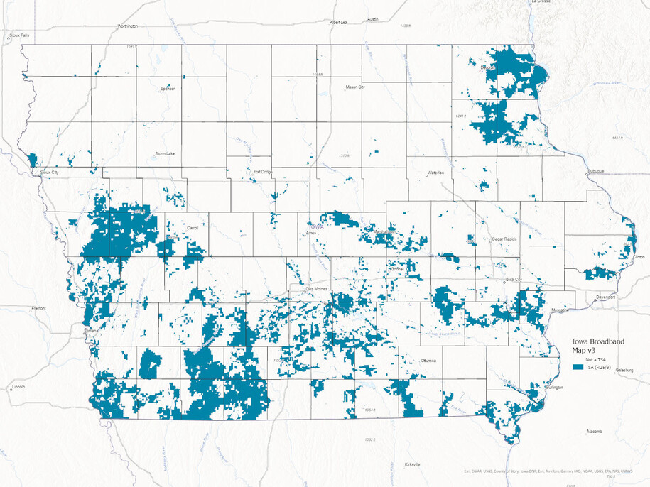
October 28, 2020
Official Publication of Statewide Broadband Availability Map V3 Pursuant to Iowa Administrative Code rule 129—20.3 and 20.4: October 28, 2020
As required by Iowa Code section 8B.10(1), as amended by 2020 Iowa Acts, Senate File 2400, the Office is required, on a periodic basis to “[determine] whether a communications service provider offers or facilitates broadband service meeting the download and upload speeds specified in the definition of targeted service area in section 8B.1 … by reference to broadband availability maps or data sources that are ... identified by the office by rule.” The Office must make this periodic determination, at least, “to the extent updated maps and data sources are available at the time, includ[ing] making such determinations prior to each round of grant applications solicited by the office pursuant to section 8B.11.” Under current law, such “findings and determinations . . . exclude mobile wireless or satellite data, capabilities, and delivery mediums” and are made at the census block level. 2020 Iowa Acts, Senate File 2400, § 3; Iowa Admin. Code r. 129—20.1.
The Office documents and communicates these determinations through the creation and publication of this Statewide “Broadband Availability Map.” See Iowa Admin. Code r. 129—20.3 and 20.4. In doing so, the Office utilizes maps and data sources made available by the Federal Communications Commission (FCC) and/or developed or produced by contractors or third parties retained or utilized by the Office for such purpose. Iowa Admin. Code r. 129—20.3. These maps and corresponding data sources represent the status of Broadband in Iowa as of July 31, 2020 (NOFA 004 section 1.2.4. “As of Date”). At the time of publication of this map, the download and upload speeds were twenty-five (25) megabits per second of download speed and three (3) megabits per second of upload speed, respectively (“25/3 Broadband”). A census block is a “Targeted Service Area” if either:
- No communications service provider facilitates broadband service at or above 25/3 Broadband as of the As of Date. Service is “facilitated” if a communication service provider would be capable of providing 25/3 Broadband to a home, farm, school, or business within a commercially reasonable time and at a commercially reasonable price upon request by a consumer; or
- The census block is not materially served or lacks meaningfully available broadband service by one or more communications service providers at or above 25/3 Broadband as of the As of Date. A census block is not “materially served” if less than 10 percent of the geographic area comprising the census block is facilitated with 25/3 Broadband as of the As of Date. “Meaningfully available” means broadband service that is facilitated to consumers on a commercially reasonable basis and without significant interruption or delay, taking into consideration product or delivery attributes or characteristics such as availability in terms of average uptime and downtime or latency or delays in the transmission of data.
Color Code/Legend
With that backdrop in mind, as further explained through the following color code/legend, this Broadband Availability Map represents the status of 25/3 Broadband in Iowa as follows:
- Clear/No Color: If a census block is clear or has no color, the maps and corresponding data sources utilized by the Office support the conclusion that 25/3 Broadband WAS materially and meaningfully available within that census block as of July 31, 2020.
- Blue: If a census block is Blue, the maps and corresponding data sources utilized by the Office support the conclusion that 25/3 Broadband was NOT materially or meaningfully available within that census block as of July 31, 2020. These census blocks are “Targeted Service Areas” or “TSAs,” as defined by Iowa Code section 8B.1, and are eligible to receive State incentives.
Version/Stage in Process
This Map represents the official publication of version 3 (“V3”) of the Broadband Availability Map. See Iowa Admin. Code r. 129—20.4(1) (“This statewide map shall be published online at ocio.iowa.gov/broadband.”). Through this official publication, the Office triggered the window for formal challenges pursuant to Iowa Administrative Code rules 20.4(1)-(3) and 20.5. A challenge process was held by the Office from October 28, 2020 through November 16, 2020. The challenge window is now closed. The Office is currently reviewing map challenges and preparing final decisions.
- Challenges Received By The Office
- Office’s administrative rules governing the publication and challenge process
- Download underlying data used in this application
View the Map